

One of the requirements of an MPO is to maintain a Public Participation Plan that is updated every 3 years. We have recently updated this document and a draft will be available for public comment. The public comment period will begin Monday, April 19, 2021 and ends on Wednesday, June 2, 2021 at 4:00 pm. The public hearing will be held on Wednesday, June 2nd from 4:00 pm to 4:30 pm via www.GoToMeeting.com. The meeting access code is 369-736-973. Attendees may also access the meeting via phone at (312) 757-3121. Questions and public input regarding these documents will be duly noted and included in the Appendix of the final documents. The hearing will be held by electronic means only and no persons will be physically present. If any member of the public wishes to attend the meeting electronically, the meeting will be available using the information above. The Public Participation Plan is available for public review online at www.heartlandmpo.org from a link on the home page. Hard copies of this document may also be requested formally in writing to David Benefiel, 739 Main Street, Anderson, Indiana 46016 prior to May 3, 2021. Oral or written comments and suggestions regarding this document may be submitted to the Anderson MPO through Wednesday, June 2nd until 4:00 PM. Submissions may also be sent to David Benefiel, Principal Transportation Planner at dave@heartlandmpo.org or by phone at (765) 640-4201. Persons with disabilities or non-English speaking persons who wish to attend the public hearing and need assistance should contact David Benefiel at least 48 hours prior to the hearing at (765) 640-4201 between 8:00 AM and 4:00 PM, Monday through Friday. Every effort will be made to make reasonable accommodations for these persons. It is the intent of the Anderson MPO to formally approve the Public Participation Plan at its regular Policy Board meeting on June 3, 2021 with the caveat that no additional public comment is received by the June 2, 2021 deadline that would require significant changes or amendments to the document.

The Clean Air Aware initiative is part of the services provided by the Madison County Council of Governments (MCCOG). The Clean Air Aware initiative focuses on improving air quality in the Indiana communities of Madison County, Fortville, and Daleville. The initiative’s purpose is educating these communities about the benefits of clean air and highlighting simple ways residents can improve air quality to better their environment, health, and economy. MCCOG is in the process of creating an informational display in their lobby to educate visitors on the importance of the Clean Air Aware program by highlighting air pollution issues, health risks, and mitigation measures. The exhibition will include posters, informational brochures, packets, and a full-size custom-designed bicycle rack. The MCCOG design team's bicycle rack pays homage to the Heartland Bikeways program the agency also runs. The Heartland Bikeways program entails bicycle trails developed in conjunction with MCCOG’s Madison County Bicycle and Pedestrian Facilities Plan, 2005-2015. The trails offer bicyclists the opportunity to explore the county’s rural farmlands, historical sites, and urban downtown areas. The inverted U-shaped design incorporates custom Clean Air Aware logos cut out in the metal panels and a spoked wheel at the top of the inverted U. The design drawings and specifications were done completely in-house by our design team and then sent to MoFab in Anderson to be fabricated. For more information about the Clean Air Aware initiative and ways you can help improve Madison County’s air quality, visit https://www.cleanairaware.com/ .

Analyzing community health can provide insight to changes in quality of life. Research has shown that where you live, work, and play impacts your overall health because the built environment influences individual choices for living an active lifestyle. Shaping the built environment to encourage more people to walk or bike can positively impact both individual and community health. Acknowledging the importance of health, MCCOG conducted a Health Impact Assessment to identify major health trends and measure health disparities across the Anderson Metropolitan Planning Area (MPA). A Health Impact Assessment or HIA is a tool that considers potential positive and negative health impacts as part of the decision-making process for plans, projects, and policies. HIAs identify health trends, disparities, and impacts by relying on scientific data, expertise, and community input. Health impacts can be further analyzed within specific areas or population groups. For government organizations and agencies, HIAs are important because they provide practical, evidence-based recommendations to increase positive health effects and mitigate negative health effects within the analysis jurisdiction. Overall, HIAs are an important tool for building in a healthy, sustainable, and equitable manner.
Welcome back to the Land Use & Design team’s #BestPracticesINPlanning series! In this post, we will be discussing where nuisance laws originated from and why they are important in community planning. Community planning is based on public interests, so citizens engage in planning processes to ensure the needs of their whole community are considered, and not just those that benefit individuals. There is some flexibility when the use of individual land is given up in exchange for creating a community where all citizens’ interests are considered. Emphasizing public interests in community planning is underpinned in English tort law whose main tenet states that “a man shall not use his property so as to harm another.” This law remained within the United States through the American Revolution and evolved over time into the concept of nuisance laws. Early common laws classified a person as causing a “nuisance” to a neighbor when one’s ownership and enjoyment of their property caused unwarranted interference with another’s ownership and enjoyment of their property. Nuisances could be common, private, or a mix of the two depending on the scope of the issues. Early examples include operating smokestacks or dust emerging from factories harming all citizens of a community. Eventually, this loosely defined concept of nuisance law became what we now know as zoning. The concept of single-use zoning, otherwise known as Euclidean Zoning, was established in New York City as a constitutional use of the government’s police powers in 1926. Since then, Euclidean Zoning has been the dominant system for establishing land uses in much of the United States. Since zoning affects all members of a community, it is our job at MCCOG to serve the public’s interests and represent their will to decision makers so both the interests of individuals and the needs of the community at large are taken into account.
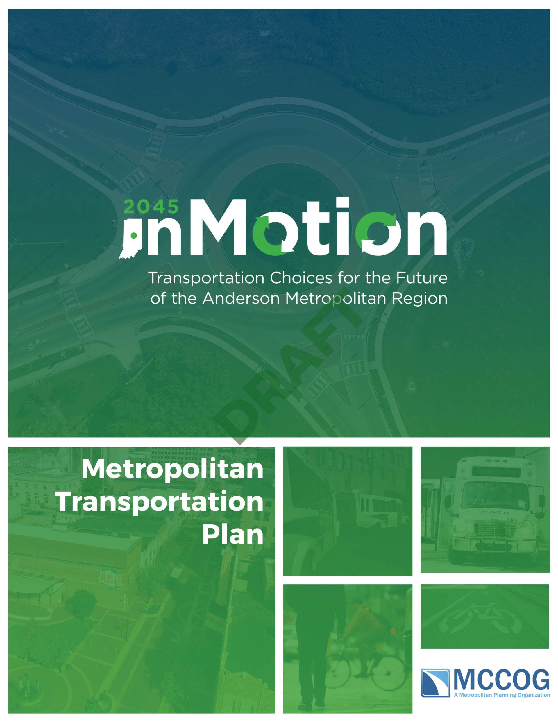
MCCOG is excited to announce the draft release of 2045 inMotion, the Metropolitan Transportation Plan (MTP) for the Anderson Metropolitan Planning Area (MPA). This document is the culmination of over 18-months gathering public input and analyzing data to create a framework for investing in the transportation system over the next 25 years. Community members are invited to join the online Regional Exhibition to provide input virtually through the process website. Participants can review a brief version of the action list, including infrastructure projects and non-infrastructure programs, policies, and plans. Feedback on the actions, the draft, and the process can be provided directly on the Regional Exhibition page to be reviewed and incorporated into the final document.
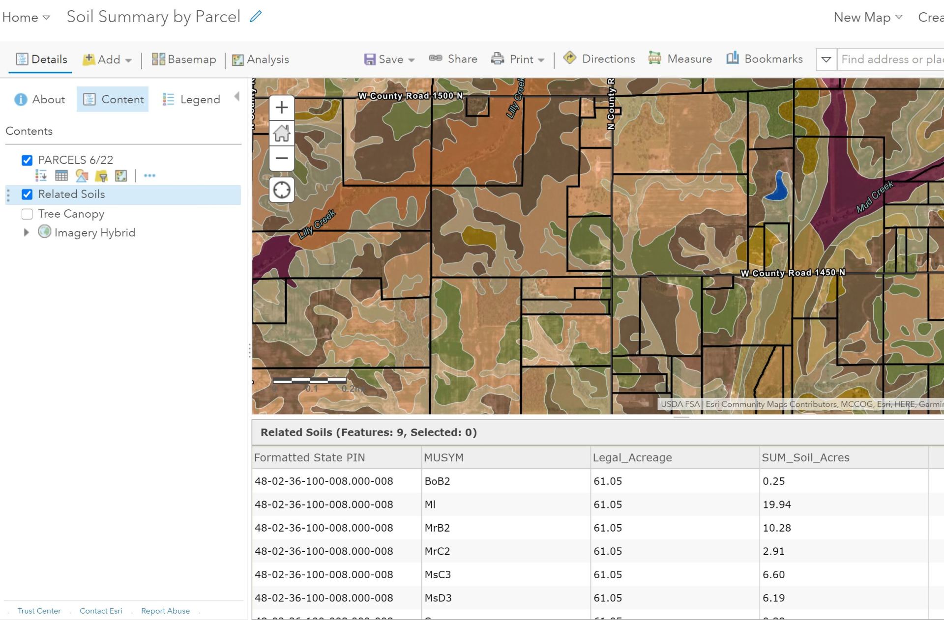
In this week’s #MorethanMapping post, we will explore one of the many ways GIS is utilized in parcel assessment. One of the many factors that determines the value of farmland is the Soil type. Depending the quality of the soil, each soil classification carries a different valuation rate. In the past, Assessors used paper maps to determine the area of each soil type within a parcel. GIS has not only simplified the process, but also made it much more accurate. Soil acreage can be calculated to the millionth decimal place. The Soil Survey data is downloaded from the USDA-Natural Resources Conservation Services-Soil Survey Geographic Database (SSURGO) and intersected with the most current parcel information. A new ‘Soils by Parcel’ layer is created and references the Parcel database, using the State PIN number. In order to streamline this process, a Model containing all the steps was created in GIS. Once changes are made to the parcels, the Model will ‘run’ the intersecting process again and recalculate the sum of soil acres within each parcel.
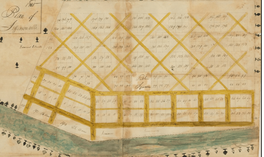
Welcome to our new ongoing series #BestPracticesINPlanning! The Land Use & Design team will be discussing different best practices in community planning specific to Madison County and Indiana based on the Indiana Chapter of the American Planning Association’s Citizens’ Planning Guide. Thoughtful planning is important for fostering and sustaining prosperous communities. Communities all over the United States have been laid out according to plans since the earliest settlements, including Jeffersonville, Indiana. Even though Jeffersonville is outside Madison County near the Kentucky border, its history demonstrates how planning for communities’ specific needs is important. Jeffersonville was originally laid out by Thomas Jefferson in 1802. The plan contained a checkerboard pattern of undeveloped and subdivided squares to create permanent open spaces. Permanent open spaces were important to Thomas Jefferson, because they would help deter the spread of Yellow Fever. Jefferson’s plan allowed for large commercial uses along the Ohio River that helped Indiana assert trade dominance in the region. However, land speculators found the plan inhibiting, so the Indiana legislature authorized replatting the land in 1816. The replatting allowed for selling more housing to settlers moving west, creating better access to the Ohio River, and establishing the Indiana Canal Company. The original grid pattern is still fundamental to Jeffersonville, but the replatting suited its practical realistic needs and allowed the city to grow organically. Madison County has also grown organically since its founding in 1823. The county was named after James Madison, even though the fourth president was not directly involved in planning it like Thomas Jefferson was in planning Jeffersonville. Madison County’s growth is attributed to reactions to various events in its history. The City of Anderson was formed into a small village when a trading post was established in the early 1830’s. Anderson remained a small village until the early 1850’s when the Indianapolis Bellefontaine Railroad arrived, which prompted the village to expand. Anderson expanded even more when natural gas was discovered in 1887, leading to the Gas Boom and following Gas Bust in 1912. General Motors (GM) and other automobile manufacturers arrived in the 1920’s following the Gas Bust, which provided many employment opportunities for county residents until the early 2000’s. However, relying so heavily on this single industry led to a sharp economic decline when GM ceased all operations in 2008. Jeffersonville demonstrates there is a distinction between idealized planning like Jefferson’s plan, and the practical realistic planning like the speculators’ replatting. Madison County demonstrates that planners must find balances to better and sustain their communities. Practical realistic planning is essential for giving community residents what they want, fostering efficient land uses, and promoting economic development. Today, we still face similar pressures and problems with planning communities as we did 200 years ago. Planners understand our communities and their histories, so they are here to propel us into the future, including MCCOG’s Land Use & Design team!

In this week’s #MoreThanMapping post we will be looking at new dynamic ways to deliver data with maps, charts, gauges, and other visual tools. Within our mapping platform, we can create on-demand, real-time data dashboards that help monitor your organization’s activities and indicators. Our dashboards offer a comprehensive, engaging view of data to provide key insights for quick decision-making. We are leveraging dashboards at MCCOG for: - Utility Data - Demographics - Asset Management - Election Results - Health Data - COVID Tracking - Permit Tracking - Crime Tracking - And more! These dashboards are fully customizable and used for many other data sources. Make sure to check out our examples of dashboards on the Projects & Resources page. If you have any questions or ideas about how to use a dashboard for your own business or organization, then reach out to our GIS & Mapping team to get started!

For this week’s #MorethanMapping post we will be exploring 3D Photos and Tours, the newest imaging technology available at MCCOG. Using the Matterport platform allows us to use our 3D camera system to scan and create replicas of any physical space. The Matterport platform creates digital assets as well as automatically stitches, makes color adjustments, and makes exposure adjustments, and more! With each scan you get: • 3D Digital Twins • 4K Photos • Guided Video Tours • 3D Point Cloud Files/PDF Floor Plans
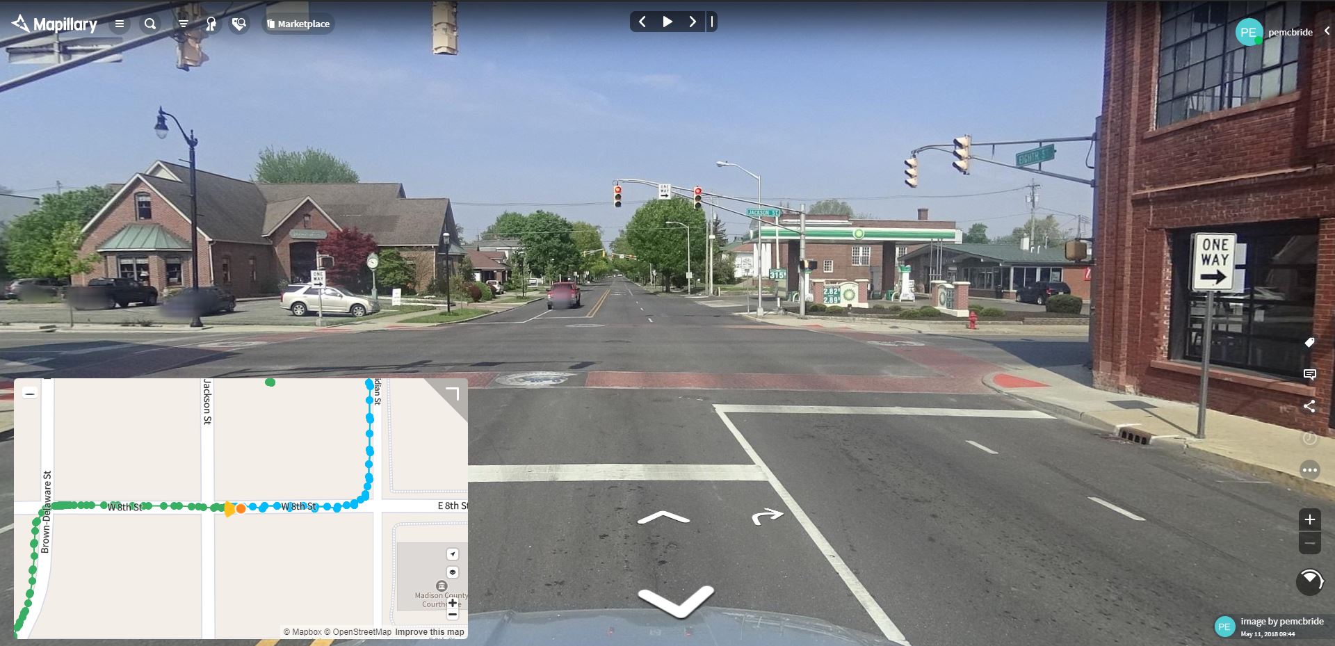
In this week’s #MorethanMapping post, we will be covering how street-level imagery can help communities collect, manage, and analyze assets. GPS-enabled cameras mounted to vehicles allows teams to drive down roads, alleys, and other paths to capture high resolution images from all angles.

