GIS & Mapping

GIS & Mapping

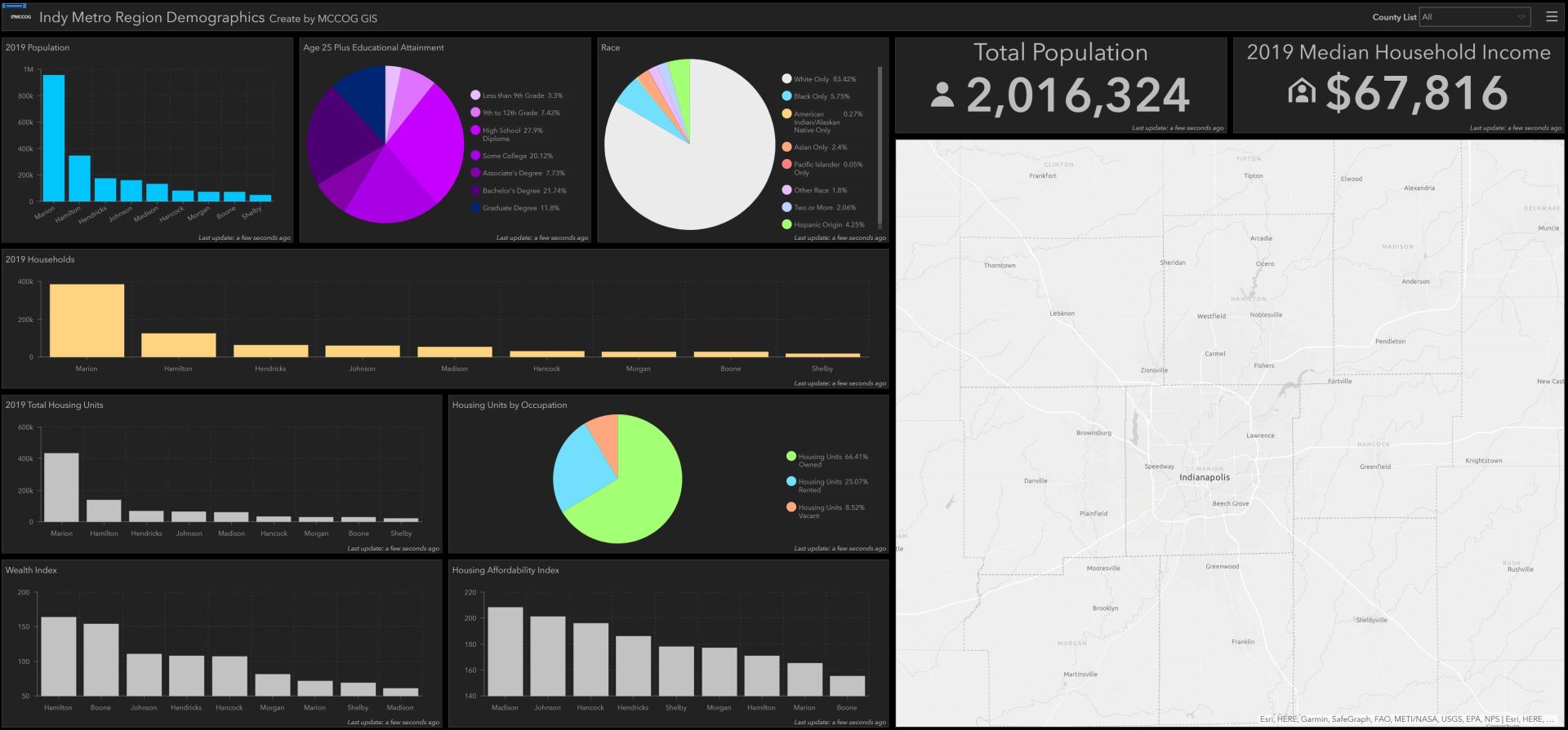
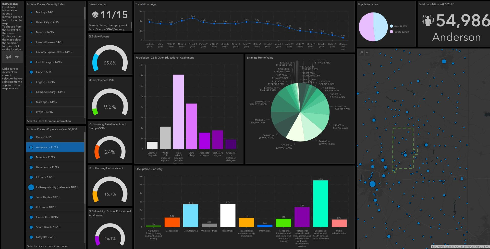
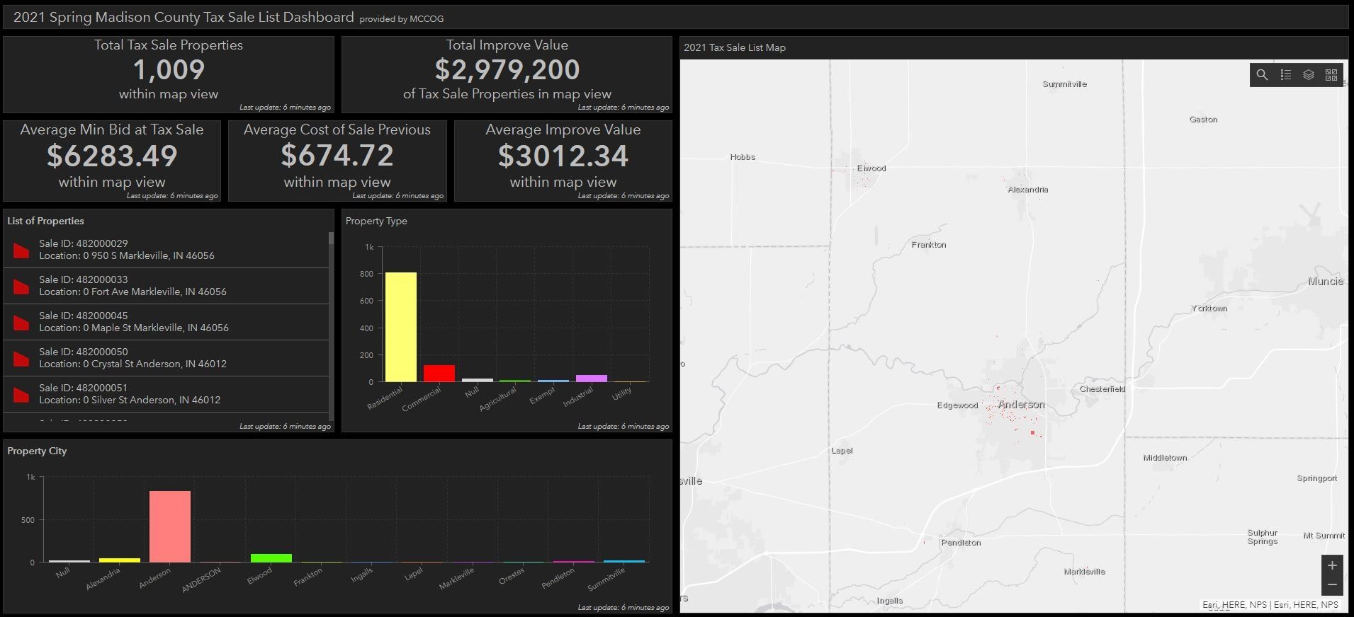
A Geographic Information System (GIS) is a framework for gathering, managing, and analyzing data. GIS is rooted in the science of geography to integrate many types of data into analyzing spatial location and organizing informational layers to produce maps, 3-D scenes, and infographics. MCCOG uses this unique capability to manage most data for Madison County and other communities within their Metropolitan Planning Area (MPA). MCCOG also has the ability to provide advanced services in coordination with GIS technologies for deepening the understandings of patterns and relationships that help community, organization, and business leaders make smarter decisions as well as improve local residents’ quality of life.
  • How Does GIS Work?

    GIS technology applies geographic science with tools for understanding and collaboration. It helps people reach a common goal: to gain actionable intelligence from all types of data.


    Maps

    Maps are the geographic container for desired data layers and analytics. GIS maps are easily shared and embedded in apps, which makes them accessible to virtually everyone everywhere.


    Data

    GIS integrates many kinds of data layers using spatial location, because most data has a geographic component. GIS data includes imagery, features, and base maps linked to spreadsheets and tables.


    Analysis

    Spatial analysis lends new perspectives to decision makers by allowing for evaluations of capabilities, estimations to make predictions, interpretations that lead to increased understandings, and much more.


    Apps

    Apps provide focused user experiences for completing work and bringing GIS to life. GIS apps work virtually everywhere: on mobile phones, tablets, web browsers, and desktops.


  • Limitations of Use

    Disclaimer

    The MCCOG makes no warranties, expressed or implied, as to the accuracy, completeness, or timeliness of this data for any use whatsoever. The MCCOG is not responsible for any errors or omissions contained in this data, or for any results obtained from the use of this information. The MCCOG may elect to discontinue this service without notice at any point in the future. Any questions regarding this data or comments regarding improvements to this site should be directed to the Madison County Council of Governments at 765-641-9482.


    Use of Data

    No person shall modify the data contained on this web page without prior written permission from the MCCOG. Any public display of the maps or data from this web page must include the Disclaimer listed above. This site only allows for the viewing and printing of map data. No data downloading is permitted. If you wish to obtain copies of any of the data contained on this web page please contact the MCCOG at 765-641-9482.


    Parcel Data

    The property information available on this web site is meant to be for mapping reference purposes only. The parcel data was created from public records that are constantly undergoing changes. If questions or problems arise regarding the parcel data, please contact the Madison County Auditors Office by telephone at 765-641-9419.


    County Zoning Data

    The County Zoning information shown on this web site was provided by the Madison County Planning Commission. If you have any questions or comments regarding the County Zoning information, please contact the Planning Department at 765-641-9541. More information about the Madison County Planning Commission can be found at: Madison County Planning Department.


    Local Community Zoning

    Please contact the municipality for zoning information. 

Projects & Resources

If you have a custom map or data request, please contact our office to set up an appointment with our GIS Analyst.  For a menu of available data for purchase click here.

GIS & Mapping Team

Rene Lawson

GIS Coordinator
Share by: